FM 1053 Schematic and Environmental (S&E), TxDOT, Odessa District
Imperial, TX
IEA WAS THE PRIME CONSULTANT FOR THIS SCHEMATIC AND ENVIRONMENTAL PROJECT TO ADDRESS A SINKING ROADBED AFFECTING THE SAFETY AND RELIABILITY OF THE STATE HIGHWAY SYSTEM.
The cause of the subsidence was associated with artesian wells located adjacent to the surface of this stretch of FM 1053. IEA performed a feasibility study, which resulted in a 3-phase approach offering options to the district for the section needing to be relocated.
Innovative and Comprehensive Data Collection
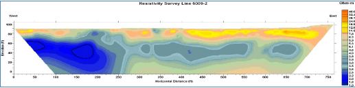
IEA used an innovative technique to conduct geophysical testing. We combined Interferometric Synthetic Aperture Radar (InSAR), a technique that maps ground deformation using radar images of Earth’s surface, with Electrical Resistivity Tomography (ERT), a test that determines water directions up to 1,000 feet in the soil.
IEA combined the LiDAR completed by 1 of our subs with the InSAR satellite imaging to observe ground movements over time in the study area. Together they created a comprehensive and complete Constraints Map.
Additional environmental research included historical document research of well activity (e.g. oil, gas, artesian), environmental resources, property ownership verification, and newspapers.
Phase 1
A study area of a 3-mile radius from the “sag” area was delineated for potential FM 1053 realignment routing. IEA field verified the data collected and brainstormed route alignment options. This allowed IEA to place avoidance around suspicious areas as we designed routes. IEA studied 23 different routes, eventually arriving at 3 feasible routes.
Public Involvement
IEA supported TxDOT in conducting a Public Meeting in Imperial using an Open House format with roll plots and markers on tables. The citizens recognized the need for the route. IEA used a Decision Matrix to compare each route against a set of MOEs, resulting in the 3 most feasible being carried forward. We presented the 3 most feasible routes to the County Judge for concurrence. IEA reviewed all information through the Decision Matrix again to screen for the Preferred Alternative.
Phase 2
IEA studied the potential for keeping FM 1053 on its existing alignment by stabilizing the “sag” area. IEA used ERT (shallow) and nondestructive Seismic surveys (deep) to analyze the “sag” area.
Phase 2A
IEA studied the potential for converting 2 local roadways (7-Mile and Buena Vista) for possible re-designation as FM 1053. IEA identified constraints using aerial survey, database research, filed verification and InSAR technology for a corridor 500-1,000’ wide. IEA conducted field verification of this data and evaluated existing conditions along these roads. IEA prepared typical sections to establish ROW needs and evaluated widening to the left, right or about the centerline.
At certain locations along the road, we diverged off the existing alignment to avoid potential future sag areas identified through constraints mapping. IEA designed a new intersection just north of Fort Stockton where the existing FM 1053 and Buena Vista connect to allow for a better and safer realignment of FM 1053 along Buena Vista and to provide safer sight distances.
IEA evaluated these routes using a Decision Matrix to determine the most promising route that would safely provide mobility between Fort Stockton and Imperial.
Location
Imperial, TX
Services Provided
Prime Consultant for Schematic and Environmental Documentation