SH 29 Schematic and Environmental (S&E), TxDOT, Austin District
Williamson County, TX
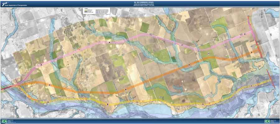
IEA Inc. was the Prime Consultant responsible for a 14-mile feasibility and schematic/environmental study.
The project limits included urban, suburban, and rural on a new location with crossings of jurisdictional waters of the San Gabriel River, and rural and urban widening of existing 2-lane to 4-lane and 6-lane.
Feasibility Study:
IEA evaluated 10 alternative alignments for the rural section of the project, attempting to use available county road ROW and carefully considering the alignment across farmlands. Our design considered the operational needs of the impacted historical farms and revised alignments to minimize impacts, especially to structures and ponds, leaving the property owner with usable remainder property.
The suburban portion of SH 29 was a widening that looked at shifting ROW takes to avoid residential, church, and park impacts. IEA’s design shifted the alignment to reduce the number of impacts and displacements to only areas around the major arterials. These impacts were a result of the thoroughfare needs for the rapidly growing area to add turn lanes and at SH 130, a 3-level interchange.
Environmental Study:
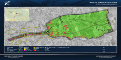
Environmental constraints documented included Southwest University, multiple churches, a high school, parks, abutting ROW, cemeteries, and historical areas. There were several historic farms impacted on the alignment.
Public Involvement:
The IEA Team presented project information at 3 Public Meetings for SH 29. At each meeting, IEA engaged citizens and documented feedback to use in the study.
The third Public Meeting was not originally planned. Due to opposition between two alternatives, IEA worked with TxDOT to schedule an additional Open House type meeting with a brief technical presentation, which presented organized charts and diagrams of the cumulative results of the previous Public Meetings to ensure the affected public and stakeholders had all the facts of the study and the reasoning for the Prefered Alternative.
Drainage Analysis:
The project included multiple San Gabriel River, Smith Branch Zone AE crossings along with Mileham and Pecan Branch Zone A crossings. Water quality provisions were a key component to the schematic development. The roadway alignment falls within the Edwards Aquifer boundaries, so to comply with TCEQ Protection Plan, vegetative filters, grassy swales, and sand filters were implemented for permanent water quality BMPs. IEA coordinated with the Georgetown AO and thoroughly reviewed maintenance logs for the frequency of road closures due to flooding by the San Gabriel River overtopping and FEMA maps.
IEA prepared the schematic-level drainage study for existing conditions and the preferred alternative for the entire drainage system along the corridor. IEA determined the drainage area for each culvert structure, determined headwater based on the design storm, and provided the data to the roadway team to evaluate the fill in the floodplain and determine if environmental mitigation was necessary.
Pictured:
Constraints Mapping (left) and Rural Segment Route Alignment Study (right).
Location
Williamson County, TX
Services Provided
Prime Consultant